Earning money with a drone is an exciting prospect, offering diverse opportunities in aerial photography, videography, and specialized services; at money-central.com, we’ll guide you through turning your drone skills into a profitable venture. This comprehensive guide explores various avenues, from capturing stunning visuals to providing essential services across industries, empowering you to soar financially with your drone.
1. What Are The Lucrative Ways To Earn Money With A Drone?
Yes, there are multiple lucrative ways to earn money with a drone by offering services like aerial photography, videography, surveying, and inspections across various industries. Drones have revolutionized numerous sectors, making tasks faster, smarter, and safer, and the demand for skilled drone pilots is soaring.
- Aerial Photography and Videography: One of the primary ways to monetize your drone is by providing aerial photography and videography services. The drone photography services market was estimated to be worth $617.6 million in 2023 and is expected to climb to nearly $3.5 billion by 2033, according to Fact.MR.
- Real Estate: Capture stunning aerial shots of properties for real estate listings, showcasing their best features and surrounding areas.
- Agriculture: Offer services like crop monitoring, thermal imaging, and aerial spraying to help farmers optimize their yields and reduce costs.
- Events: Cover weddings, concerts, and sporting events from a unique aerial perspective, creating memorable footage for clients.
- Surveys and Inspections: Conduct aerial surveys and inspections of infrastructure, construction sites, and other areas, providing valuable data for businesses and organizations.
These opportunities highlight the diverse potential for drone pilots to generate income across various sectors.
2. What Are The Top Drone Career Opportunities Available Today?
The top drone career opportunities today include content creation for stock images and YouTube, as well as employment in agriculture, construction, surveying, infrastructure inspection, mining, forestry, and real estate. These diverse roles cater to various skill sets and interests within the drone industry.
- Content Creation:
- Stock Images: Sell aerial photos and videos to stock image websites like Getty Images and Shutterstock.
- YouTube Channels: Create drone-related content, such as tutorials, reviews, and aerial footage, and monetize it through sponsorships and advertising.
- Weddings and Events: Offer aerial photography and videography services for weddings, parties, and other special occasions.
- Employed Drone Pilot:
- Agriculture: Monitor crops, assess plant health, and apply pesticides or fertilizers using drones.
- Construction: Survey construction sites, track progress, and create 3D models using drone imagery.
- Surveying and Mapping: Generate accurate maps and models of land and infrastructure using drone-based surveying techniques.
- Infrastructure Inspection: Inspect bridges, power lines, and other infrastructure for damage or wear using drones equipped with cameras and sensors.
- Mining: Survey mine sites, monitor operations, and assess environmental impact using drone technology.
- Forestry: Monitor forest health, assess timber volume, and detect illegal logging activities using drones.
- Real Estate Photography: Capture aerial photos and videos of properties for real estate listings and marketing materials.
- Drone Instruction: With the increasing demand for drone pilots, consider teaching others how to safely and effectively pilot drones.
 Drone aerial view for construction site
These opportunities demonstrate the breadth of career paths available to skilled and certified drone pilots.
3. How Are Drones Transforming The Agriculture Industry?
Drones are transforming the agriculture industry by enabling precise crop monitoring, efficient spraying, and data-driven decision-making, leading to reduced costs, improved crop quality, and increased yield rates. Previously, agriculture relied on manual field surveys, a laborious process providing limited information; drones now offer an aerial perspective, revolutionizing farming practices.
-
Crop Monitoring: Drones equipped with cameras and sensors can capture high-resolution images and videos of crops, allowing farmers to detect issues such as disease, pests, and nutrient deficiencies early on.
-
Precision Spraying: Drones can be programmed to spray pesticides, fertilizers, and other treatments directly onto crops, with precision and accuracy. This targeted approach reduces waste, minimizes environmental impact, and optimizes crop health. Specialized drones like the Mavic 3 Multispectral can measure sunlight and nutrient levels, guiding precise application of fertilizers and pesticides, according to DJI.
-
Data-Driven Decision Making: The data collected by drones can be used to create detailed maps and models of fields, providing farmers with valuable insights into crop health, soil conditions, and other factors. This information can be used to make informed decisions about irrigation, fertilization, and other management practices.
Spraying drones can deploy materials with precision:
- Desiccants
- Seeds
- Pesticides
- Fertilizers
- Herbicides
- Fungicides
By leveraging drone technology, farmers can improve their efficiency, reduce their costs, and increase their yields, leading to a more sustainable and profitable agricultural industry.
4. In What Ways Do Drones Enhance Surveying & Mapping Processes?
Drones enhance surveying and mapping processes by providing rapid data acquisition, access to inaccessible locations, and eliminating the need for human operators in hazardous environments, resulting in faster, safer, and more accurate surveys. Aerial surveying and mapping is a rapidly growing industry, estimated to be worth $617.6 million in 2023 and expected to reach nearly $3.5 billion by 2033, per Fact.MR.
- Rapid Data Acquisition: Drones can capture large amounts of data in a fraction of the time compared to traditional surveying methods. This allows surveyors to complete projects faster and more efficiently.
- Access to Inaccessible Locations: Drones can access areas that are difficult or dangerous for humans to reach, such as steep slopes, dense forests, and hazardous industrial sites. This expands the scope of surveying and mapping projects.
- Elimination of Human Operators in Hazardous Environments: By using drones, surveyors can avoid the risks associated with working in hazardous environments, such as exposure to toxic chemicals or dangerous terrain.
- Variety of Deliverables: Depending on the data sensors and surveying software used, drone surveying can produce a variety of deliverables, including:
- 2D and 3D orthomosaic maps
- 3D models
- Thermal surveys
- LiDAR data
- Multispectral maps
 Drone Mavic 3E with RTK for surveying and mapping
Drones equipped with real-time kinematics (RTK) and post-processing kinematics (PPK) capabilities can achieve survey-level accuracy for high-precision applications.
5. What Role Do Drones Play In Modern Construction Projects?
Drones play a crucial role in modern construction projects by providing real-time data, enabling Building Information Modeling (BIM), monitoring project progress, and conducting aerial inspections, leading to reduced errors, omissions, and rework. Drones provide an efficient and safe way to survey job sites and keep stakeholders updated.
- Real-Time Data: Drones can capture real-time data on construction sites, providing project managers with up-to-date information on progress, materials, and equipment.
- Building Information Modeling (BIM): Drone surveying can provide critical data that integrates with BIM, a digital planning technology that allows contractors to view project progress and reduce errors.
- Project Progress Monitoring: Drones can be used to monitor the progress of construction projects over time, allowing project managers to identify potential delays or issues early on.
- Aerial Inspections: Drones can conduct aerial inspections of construction sites, identifying potential safety hazards or quality control issues.
- 3D Point Clouds and Accurate Digital Models: Drones can create 3D point clouds and accurate digital models of construction sites, providing valuable data for planning and design.
- Stockpile Volume Measurements: Drones can measure stockpile volumes, helping contractors track materials and manage inventory.
Drones benefit contractors before, during, and after a job, offering a comprehensive solution for construction site management.
6. How Are First Responders Utilizing Drones For Emergency Response?
First responders utilize drones for emergency response in disaster relief and search-and-rescue missions by producing 3D maps, searching for victims, assessing damage, and providing real-time situational awareness. The increased demand for drone pilots in emergency services means ample opportunities for qualified individuals, according to FireRescue1.
-
3D Mapping: Drones can quickly create 3D maps of disaster areas, providing first responders with a detailed understanding of the terrain and infrastructure.
-
Search and Rescue: Drones equipped with thermal cameras can help locate victims in low-visibility conditions, such as fog, smoke, or darkness. Thermal imaging can see much greater distances than other low-light camera technologies.
-
Damage Assessment: Drones can assess the extent of damage to buildings, infrastructure, and the environment, helping first responders prioritize their efforts.
-
Real-Time Situational Awareness: Drones can provide real-time video feeds and images to first responders, giving them a clear picture of the situation on the ground.
A first responder drone can also:
- Create before/after maps of a disaster area.
- Take photos and videos for news coverage and communications.
- Assist firefighters in locating hot spots.
By using drones, first responders can improve their efficiency, reduce their risks, and save lives.
7. What Drone Training And Certifications Are Essential For Professionals?
Essential drone training and certifications for professionals include obtaining a Remote Pilot Certificate from the Federal Aviation Administration (FAA), which requires passing a certification test and meeting specific age requirements. All professional drone pilots need FAA certification to obtain a remote pilot certificate.
- FAA Part 107 Certification: In the U.S., drone pilots must obtain a Part 107 Remote Pilot Certificate from the FAA to operate drones commercially. To be eligible for this certification, you must:
- Be at least 16 years old
- Pass the FAA Part 107 knowledge test
- Undergo a Transportation Security Administration (TSA) background check
- Unmanned Aerial Systems (UAS) Training: Completing a training course in unmanned aerial systems (UAS) can help you prepare for the FAA Part 107 knowledge test and develop the skills necessary to operate drones safely and effectively.
- Recurring Exam: Your certificate is valid for 24 months, after which you must take a recurring exam to prove you have retained the necessary knowledge.
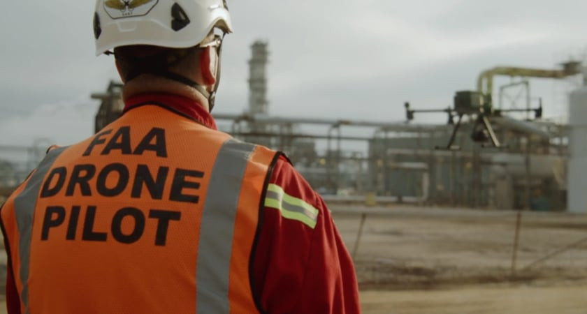 FAA drone pilot during a training session
These certifications and training programs ensure that drone pilots have the knowledge and skills to operate drones safely and responsibly.
8. How Can Someone Become A Certified Drone Pilot Successfully?
To become a certified drone pilot successfully, start with inexpensive practice drones, register your drone with the FAA, learn drone regulations, take a training course, pass the FAA Part 107 test, and stay updated on local laws. According to the Pilot Institute, these steps are crucial for a successful drone piloting career.
- Practice with Inexpensive Drones: Before investing in expensive equipment, practice flying with inexpensive drones to develop your skills and get a feel for drone operation.
- Register Your Drone with the FAA: All drones weighing over 0.55 pounds must be registered with the FAA, even if used for recreational purposes. You can register your drone online through the FAA DroneZone website.
- Learn Drone Regulations: Familiarize yourself with FAA regulations and guidelines for drone operation, including airspace restrictions, altitude limits, and operating procedures.
- Take a Training Course: Enroll in a Part 107 training course to learn about drone technology, regulations, and best practices. These courses can help you prepare for the FAA Part 107 knowledge test and develop the skills necessary to operate drones safely and effectively.
- Pass the FAA Part 107 Test: The FAA Part 107 test is a 60-item multiple-choice exam that assesses your knowledge of drone regulations, airspace, weather, and other important topics. A passing score is 70% or higher.
- Stay Updated on Local Laws: In addition to federal regulations, be aware of any local laws or ordinances that may restrict drone operations in your area.
By following these steps, you can successfully become a certified drone pilot and pursue a career in this exciting and growing field.
9. What Steps Should A Certified Drone Pilot Take After Certification?
After certification, a drone pilot should master editing software, specialize in a niche, build a portfolio, network with potential clients, and stay updated with industry trends and regulations. Post-certification, your focus shifts to creating a high-quality product with your drone.
- Master Editing Software: Enhance your raw footage by becoming proficient in video and photo editing software. This skill is crucial for delivering professional-quality media to clients.
- Specialize in a Niche: Focus on a specific area of drone services, such as real estate photography, construction surveying, or agricultural monitoring. Specializing can help you stand out from the competition and attract clients in a particular industry.
- Build a Portfolio: Showcase your best work by creating a portfolio of aerial photos, videos, and other drone-related projects. A strong portfolio can help you demonstrate your skills and attract potential clients.
- Network with Potential Clients: Attend industry events, join online forums, and connect with potential clients through social media to build relationships and generate leads.
- Stay Updated with Industry Trends and Regulations: The drone industry is constantly evolving, so it’s important to stay up-to-date on the latest trends, technologies, and regulations. Attend conferences, read industry publications, and participate in online communities to stay informed.
Consider dedicating time to editing for free to gain experience, as suggested by Indeed.
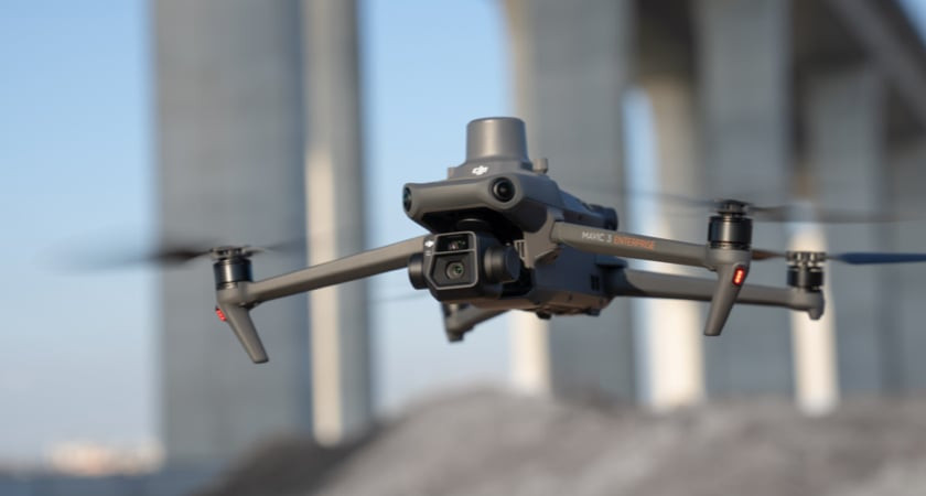
10. Which Drones Are Recommended For Individual Owners Looking To Earn?
For individual owners looking to earn money with a drone, the DJI Mavic 3E is highly recommended due to its high-quality camera, mechanical shutter, rapid mapping capabilities, and extended flight time. The better your media looks, the more it’ll be worth.
- DJI Mavic 3E: This model is an excellent choice for creating aerial footage due to its:
- Wide-angle 4/3 CMOS, 20MP sensor
- Mechanical shutter to reduce motion blur during survey flights
- 0.7-second interval shooting for rapid mapping
- 12 MP zoom camera with 56x hybrid zoom
- Approximately 45 minutes of flight time before needing a recharge
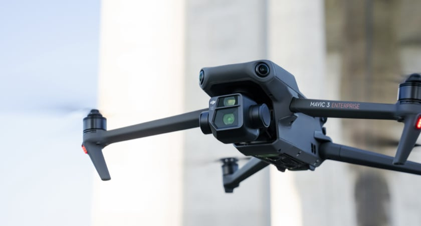 DJI Mavic 3E
Investing in a high-quality drone like the DJI Mavic 3E is essential for delivering professional-grade services and maximizing your earning potential.
11. What Income Can Be Realistically Expected As A Drone Pilot?
A drone pilot can realistically expect to earn an average hourly rate of $20 with less than one year of experience, increasing to $27 with 5-9 years and $36 with 10 or more years of experience, according to Payscale. The quality and type of aerial photographs can significantly impact earnings, ranging from $75 to $200 per photo, per Financial Wolves, while videos can range from $500 to $1,000.
- Beginner Pilots (Less than 1 year experience): $20 per hour
- Experienced Pilots (5-9 years experience): $27 per hour
- Highly Experienced Pilots (10+ years experience): $36 per hour
The annual salary for a drone pilot averages around $50,000, but can vary depending on the type of work and location. Full-time dedication can reasonably yield $2,000 to $3,000 per week, with potential for $4,000 or more per project when factoring in editing costs.
12. What Essential Steps To Ensure Success In Drone Career?
To ensure success in a drone career, master piloting skills, obtain necessary certifications, invest in quality equipment, specialize in a niche, network with industry professionals, and continuously adapt to evolving technologies and regulations. The FAA emphasizes safe and responsible drone piloting, requiring proof of proficiency and adherence to regulations.
- Master Piloting Skills: Develop advanced drone piloting skills through continuous practice and training to ensure safe and efficient operations.
- Obtain Necessary Certifications: Acquire all required certifications, such as the FAA Part 107 Remote Pilot Certificate, to legally operate drones for commercial purposes.
- Invest in Quality Equipment: Purchase high-quality drones and accessories that meet the specific needs of your chosen niche.
- Specialize in a Niche: Focus on a particular area of drone services, such as aerial photography, surveying, or inspections, to build expertise and attract clients.
- Network with Industry Professionals: Attend industry events, join online communities, and connect with potential clients and partners to build relationships and generate leads.
- Continuously Adapt: Stay informed about the latest advancements in drone technology, regulations, and best practices, and adapt your skills and services accordingly.
FAQ: Frequently Asked Questions
-
Is a drone business profitable?
Yes, a drone business can be profitable, offering diverse services like photography, surveying, and inspections across industries, with a growing market demand.
-
How much do drone photographers make?
Drone photographers can earn between $75 and $200 per aerial photograph, with potential for $2,000 to $3,000 per week with experience, depending on skill and market demand.
-
What are the best drones for making money?
The DJI Mavic 3E is one of the best drones for making money due to its high-quality camera, mechanical shutter, rapid mapping capabilities, and extended flight time.
-
What certifications do I need to fly a drone commercially?
You need an FAA Part 107 Remote Pilot Certificate to fly a drone commercially in the United States, requiring you to pass a knowledge test and meet other requirements.
-
How do I find clients for my drone business?
You can find clients by networking, building a portfolio, specializing in a niche, and marketing your services online and at industry events.
-
What are the legal considerations for flying drones commercially?
Legal considerations include FAA regulations, airspace restrictions, privacy laws, and local ordinances, all of which must be adhered to for commercial drone operations.
-
What insurance do I need for my drone business?
You need liability insurance to cover potential damages or injuries caused by your drone operations, with coverage amounts varying depending on the scope and risk of your services.
-
Can I make money with drone racing?
Yes, you can make money with drone racing through sponsorships, prize money, and endorsements, although it requires significant skill and investment.
-
How can drones be used in real estate to make money?
Drones can be used in real estate to create stunning aerial photos and videos of properties, providing unique perspectives that attract buyers and increase property value.
-
What are the best editing software for drone footage?
The best editing software for drone footage includes Adobe Premiere Pro, Final Cut Pro, and DJI Terra, offering tools for enhancing and processing aerial videos and images.
The sky is the limit when it comes to drone career opportunities; as a professional drone pilot, you can carve out a lucrative and rewarding career. Remember that you will need to dedicate time to studying and mastering your skills before becoming certified.
Visit money-central.com for more information and resources on managing your finances effectively. Discover articles, tools, and expert advice tailored to your financial goals. Take control of your financial future today with money-central.com, where you can access articles on budgeting, saving, and investing, alongside tools for financial planning and expert advice.
Address: 44 West Fourth Street, New York, NY 10012, United States.
Phone: +1 (212) 998-0000.
Website: money-central.com.